
Introduction to the
Circumpolar Arctic Vegetation Mapping Project
Overview - Download Map - Download Data - About the CAVM - Glossary - Credits - Awards
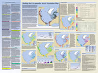
The Circumpolar Arctic Vegetation Map (CAVM) project is an international effort to map the vegetation and associated characteristics of the circumpolar region, using a common base map. The base map is a false color infrared image created from Advanced Very High Resolution Radiometer (AVHRR) satellite data. Get a more detailed overview at About the CAVM.
See the Toolik-Arctic Geobotanical Atlas for more information about CAVM map themes, map data, and images.
Download Map • Download Data

Suggested Citation:
CAVM Team. 2003. Circumpolar Arctic Vegetation Map. (1:7,500,000 scale), Conservation of Arctic Flora and Fauna (CAFF) Map No. 1. U.S. Fish and Wildlife Service, Anchorage, Alaska.
ISBN: 0-9767525-0-6, ISBN-13: 978-0-9767525-0-9
Funding:
This project was funded by the National Science Foundation Arctic Transitions in the Land-Atmosphere System (ATLAS) project (OPP-9732076)